
Why Ground-Truth Sensors Matter
Weather models are built to describe a region — not your soil. We compared ground-truth sensor readings against modelled weather data at the same coordinates, and the gap is bigger than most people expect: in temperature, in moisture, and in a metric (soil EC) that weather data can’t see at all.
This is a case study, not a controlled trial. The detailed comparisons below come from two sites: a California golf course over one month, and a Long Island site over one week. We’ve also checked the soil-temperature result across 50 courses in different regions — that section is at the end.
Key Takeaways
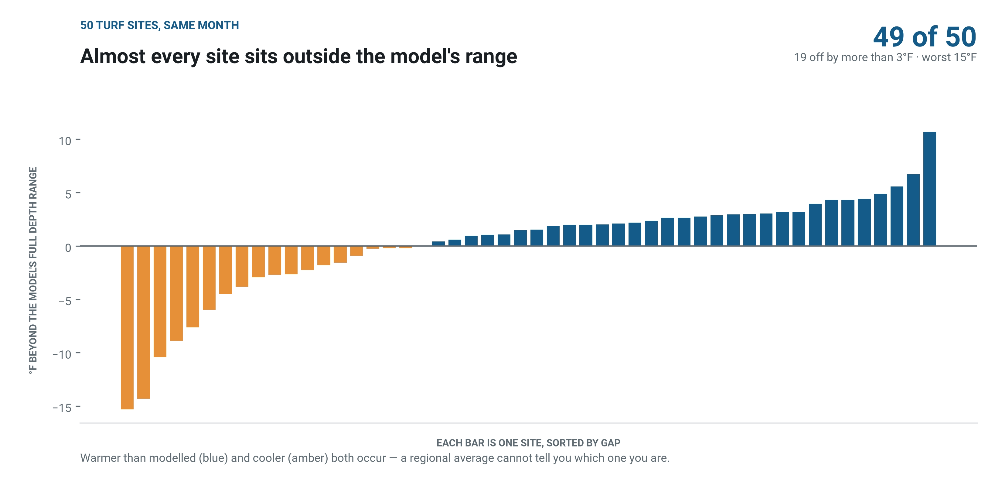
- Modelled soil temperature doesn’t land on your soil. Across 50 sites, 49 fell outside the model’s range entirely — some by more than 10°F, in both directions.
- Soil moisture is where ground-truth data adds the most value. Any irrigated site will show a big gap, because models can’t see water that was applied.
- Even within a single site, conditions vary from sensor to sensor just a few hundred yards apart. No regional model can capture that.
- Soil EC isn’t available from weather models at all. Where salinity affects plant health, in-ground sensors are the only way to get this data.
Weather Data vs a Single Spiio™ GCX Sensor
Our example is a California golf course, compared against weather data for the same coordinates over one month. Weather models estimate soil conditions across a wide area — roughly a 20-mile grid cell. Spiio measures actual conditions at a specific point and depth.
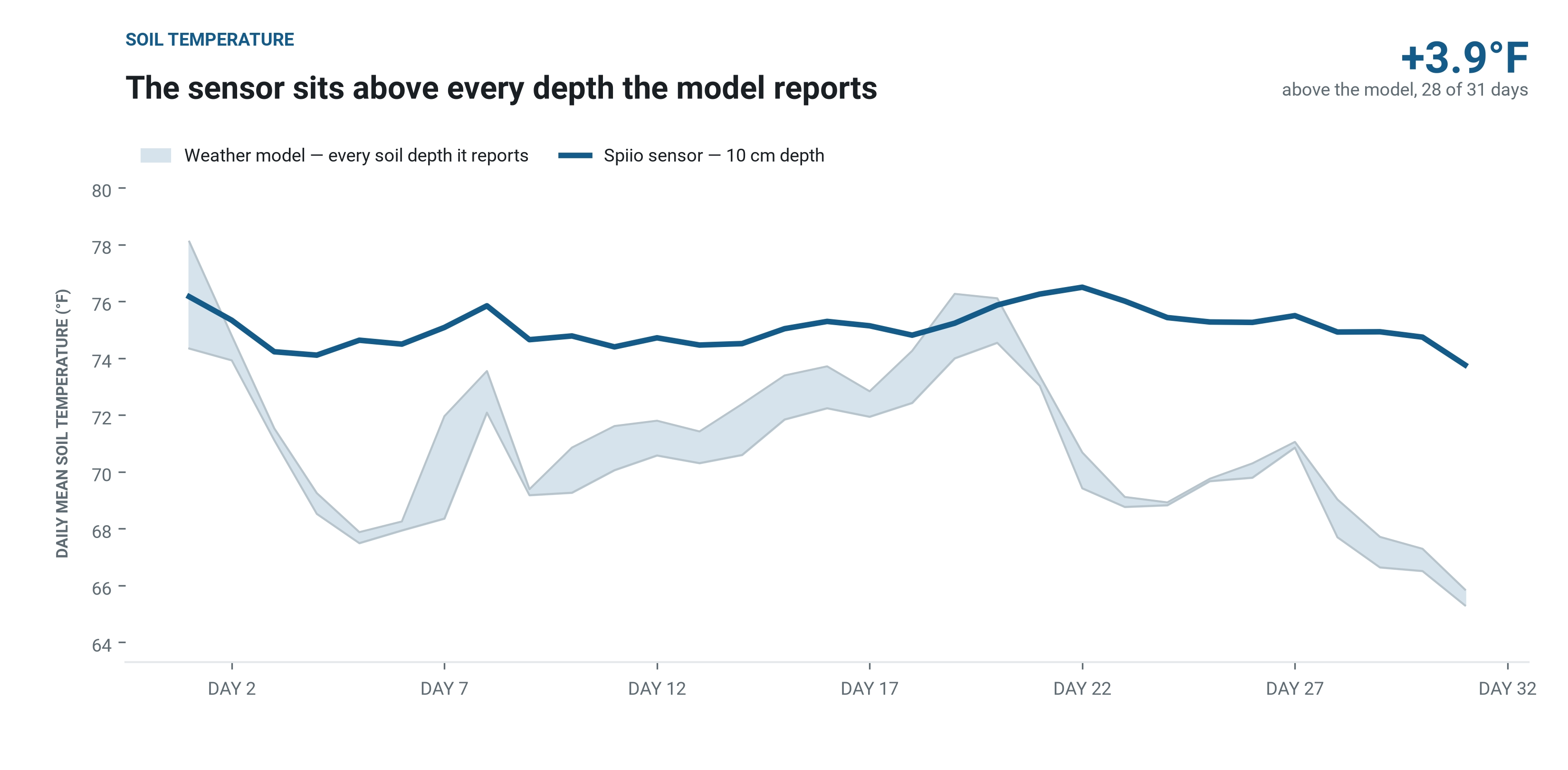
Depth matters here, so it’s worth being explicit. This probe sits at 10 cm. Weather models don’t report a single soil temperature; they report fixed layers — a shallow one and a deeper one — and those two can differ by more than 20°F on the same afternoon. Pick the flattering layer and you can prove almost anything. So we compared the sensor against the full range the model offers, top to bottom.
The sensor sits above every depth the model reports
There’s no depth setting that reconciles the two. Whichever layer you read, the sensor is warmer.
That matters because soil temperature drives timing: pre-emergent windows, green-up, root growth, insect emergence. Those decisions key off thresholds, and a few degrees moves a threshold crossing by days.
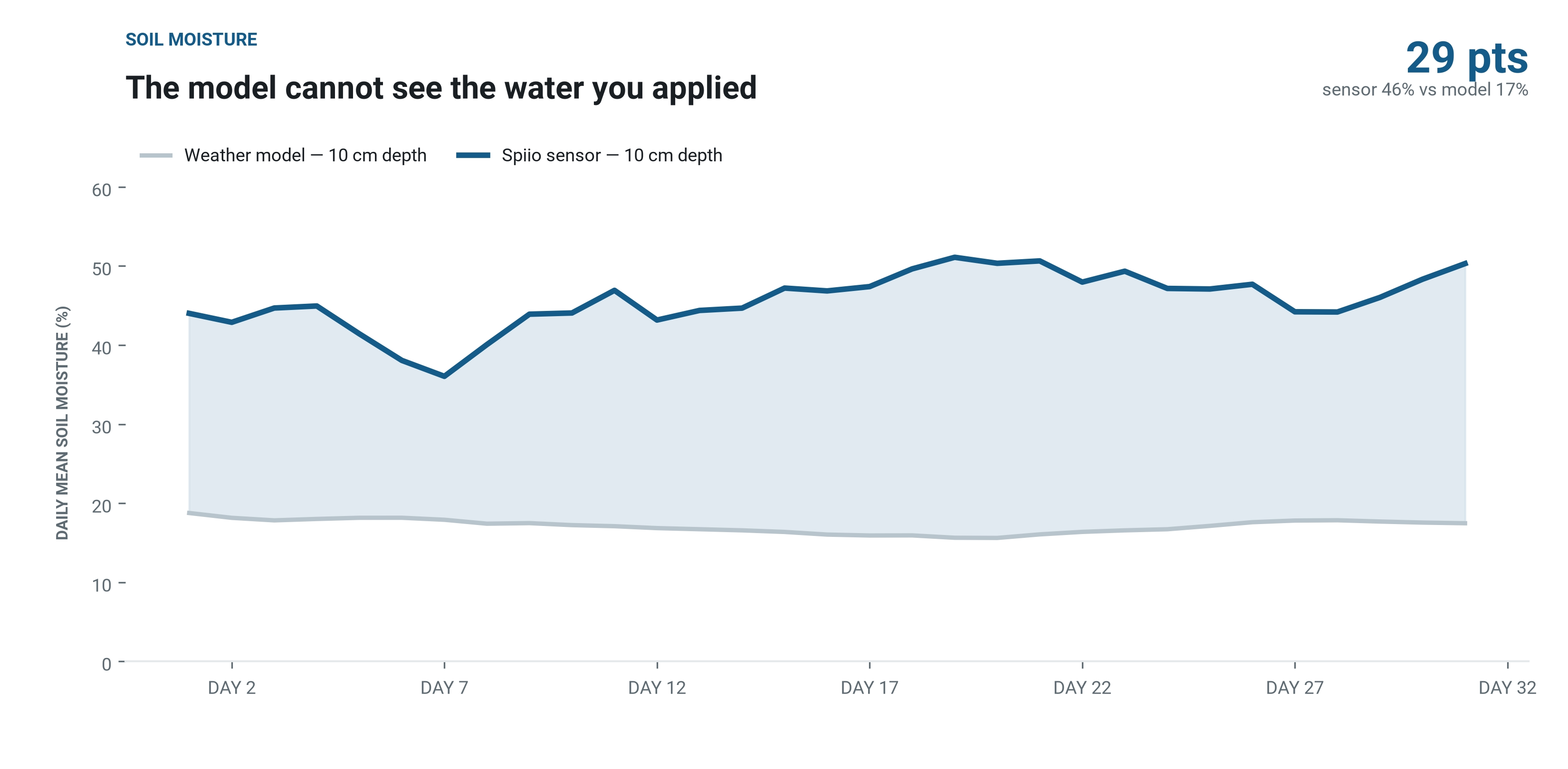
The model cannot see the water you applied
Weather models account for precipitation and modelled evapotranspiration. They have no way of knowing your irrigation ran last night, so on any site you put water on, modelled moisture describes a field that was never watered.
This is the clearest case for ground-truth sensing, and it applies anywhere water is applied deliberately: golf courses, sports fields, commercial landscapes and campuses, parks, production fields, urban tree plantings.
Sensor-to-Sensor Variation Within a Single Site
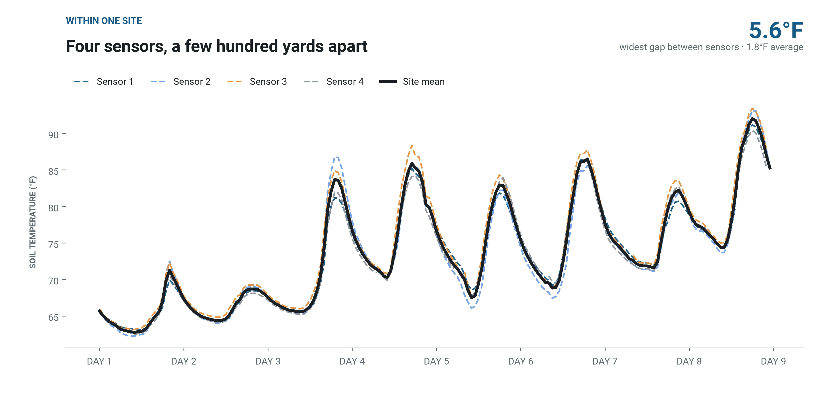
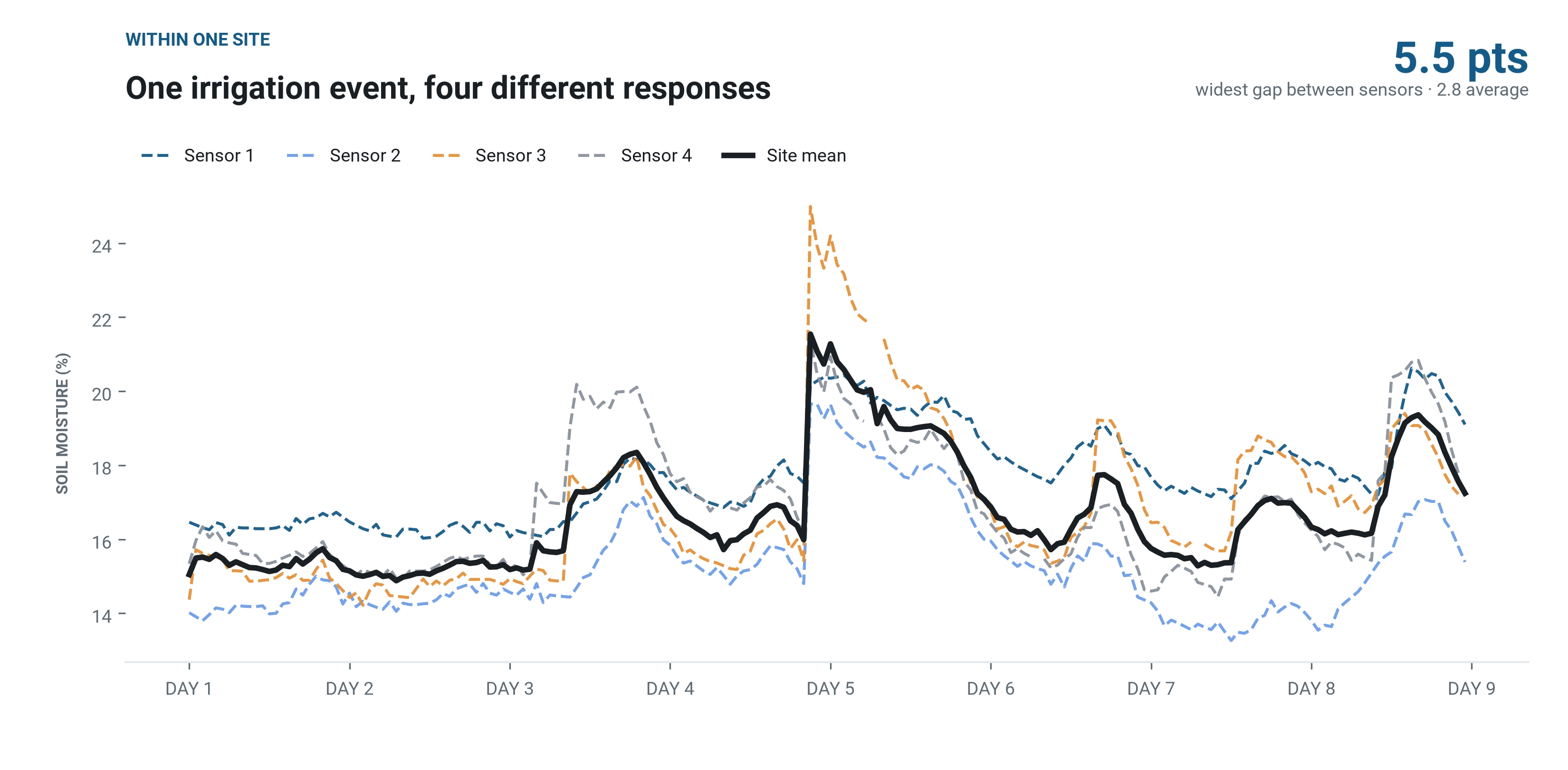
At a site on Long Island, NY, we have 4 Spiio™ GCX sensors within a few hundred yards of each other. All four sit inside the same weather grid cell, so a regional model assigns them one value. The dashed lines are individual sensors; the solid line is the site mean.
Four sensors, a few hundred yards apart
Microclimate — aspect, shade, drainage, traffic — separates sensors that a model cannot tell apart. Each Spiio GCX sensor reports the conditions where it actually sits.
One irrigation event, four different responses
On Day 5 moisture spikes across the whole site. The sensors don’t agree on how high it goes, and they don’t agree on how fast it drains. That divergence is the useful part: it says different areas are holding water differently, which is a management decision a single site-wide number can’t support.
Salinity varies most — and models never report it
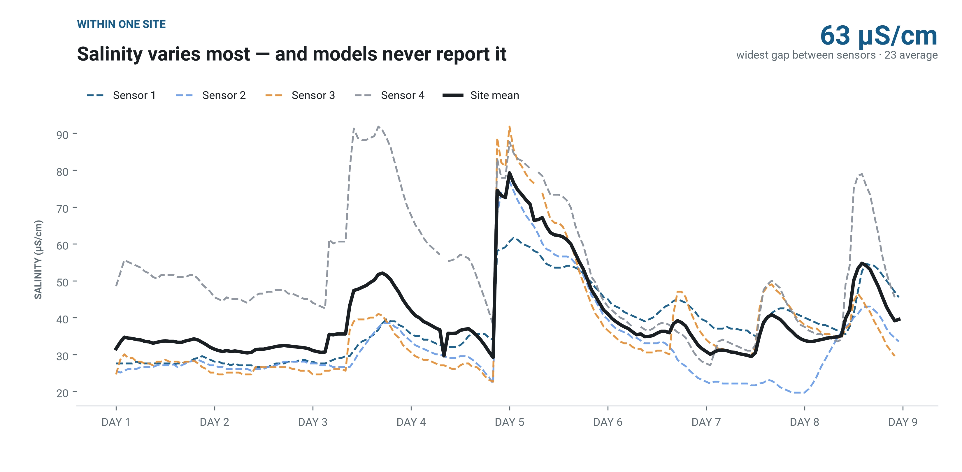
EC moves with water content, so the Day 5 event lifts every sensor — then they decline at different rates. One sensor runs close to double the others for much of the week.
There’s no weather-model equivalent to compare against here, because soil EC isn’t modelled at all. Where salinity affects plant health, this information exists only if something is in the ground measuring it.
Is This Just One Site? We Checked 50
A single course is an illustration. So we ran the same soil-temperature comparison across 50 turf sites in different regions over the same month, each sensor measured against the full depth range its local model offers.
Almost every site sits outside the model’s range
The direction isn’t consistent, and that’s the finding. Some sites read warmer than modelled, some cooler. A regional model is reasonable on average across a region — which is exactly why it can’t tell you what’s happening at yours. The averaging is the mechanism, not a defence.
Knowing your region’s average soil temperature doesn’t tell you your own offset, and nothing in the model reveals which direction you sit.
The Bottom Line
Weather data can tell you what’s happening in the region. It can’t tell you what’s happening in your soil, at your depth, on your specific site — and it definitely can’t tell you that you irrigated last night. Ground-truth sensors close that gap, and they reveal how much variation exists even within a single site that a regional model would treat as one uniform number. If you’re making decisions based on what’s actually in the ground, that’s the data you need.